I am in need of a B4X library for openseamap, similar to work Warwound has done.
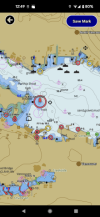
In addition to displaying a nautical chart, it needs the following functions:
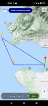
Add Markers from bitmap. Labels would be nice to have.
Add polylines
Get a Lat Long point from a "bullseye" in the center of the map by zooming and panning to a location. See attachments.
That is about it. I am prepared to pay a reasonable fee, and do not require ownership of the library, just the right to use it in my apps.
I will be using it in B4A, B4I, and possibly B4J.
Thanks for any suggestions or offers.
Touchsquid
Edit:
Problem solved by adding OpenSeaMap tileoverlay on Googlemaps, which has all the other features needed.
In addition to displaying a nautical chart, it needs the following functions:
Add Markers from bitmap. Labels would be nice to have.
Add polylines
Get a Lat Long point from a "bullseye" in the center of the map by zooming and panning to a location. See attachments.
That is about it. I am prepared to pay a reasonable fee, and do not require ownership of the library, just the right to use it in my apps.
I will be using it in B4A, B4I, and possibly B4J.
Thanks for any suggestions or offers.
Touchsquid
Edit:
Problem solved by adding OpenSeaMap tileoverlay on Googlemaps, which has all the other features needed.
Attachments
Last edited:
