Hi
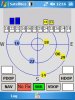
I wish to share with this great forum a section of a GPS application, which I closed as a stand alone application.
It shows the position map of the GPS satellites, the S/N ration and precision parameters PDOP,HDOP,VDOP, as well as type of navigation enabled (2D or 3D). It can also record to a file all the strings from the GPS reciever.
The program uses GPS strings which are not included in the B4PPC GPS library.
There are some blocked links like to GPSStream or GPS_detect, these can be elaborated if you want to use it.
I hope it may serve someone to improve his applications.
Alfcen - Thank you for anjin - it helped me a lot")
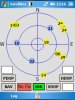
I wish to share with this great forum a section of a GPS application, which I closed as a stand alone application.
It shows the position map of the GPS satellites, the S/N ration and precision parameters PDOP,HDOP,VDOP, as well as type of navigation enabled (2D or 3D). It can also record to a file all the strings from the GPS reciever.
The program uses GPS strings which are not included in the B4PPC GPS library.
There are some blocked links like to GPSStream or GPS_detect, these can be elaborated if you want to use it.
I hope it may serve someone to improve his applications.
Alfcen - Thank you for anjin - it helped me a lot