Hi Guys
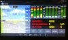
I've designed a EFIS (Electronic Flight Information System) using Raspberry and Arduino for Non Type Certified Aircraft, monitoring there instruments/sensors and display on a Tablet via bluetooth. (See attached Images)
This design runs success full for a couple of months on various Type Light Sport Aircraft and Microlights.
The need arises now for a Mapping System/Route planning. I though of Google Maps, but wonder if there is some kind of other software like (Xcsoar) or something FREE and similar for aviation, that somebody implemented into a Android App.
Comments/suggestion welcome
Thanks
Danie