With
I can superimpose an image on a map created with B4XMap.
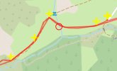
However the image is not positioned in the exact coordinate, but slightly higher.
This is very evident if the image is to be superimposed exactly on a GPS track (see attachment)
The midpoint of the bottom side of the image is placed at coordinates (lt,lg) with a not very nice effect.
Can this problem be remedied?
Thanks in advance.
B4X:
shapes.Add(coMapUtilities.instanceShapeImage(fcvMap,coMapUtilities.initShapeImage(coMapUtilities.initLatLng(Lt,Lg),xui.LoadBitmapResize(File.DirAssets,"Point_OK.png",24dip,24dip,True),0,"OK")))However the image is not positioned in the exact coordinate, but slightly higher.
This is very evident if the image is to be superimposed exactly on a GPS track (see attachment)
The midpoint of the bottom side of the image is placed at coordinates (lt,lg) with a not very nice effect.
Can this problem be remedied?
Thanks in advance.