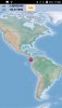
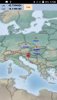
Fascinated with ScaleImageView I have to made this little code (w_map.zip).
ScaleImageView library was created by "agraham" and link is here:
 www.b4x.com
The code is not perfect but you can see how to use ScaleImageView for offline mapping.
You can use jpg/jgw , png/pgw raster map world file format (map tiles are not needed).
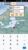
You can also draw points, polylines (as path) and polygons (as path) above the raster.
Change w.jpg and w.jgw and use your own jpg and jgw.
Use also your own txt file.
You can also use the GPS library with the code and much more.
Please be free to ammend the code or add some another examples of the code.
agraham thanks for ScaleImageView.
ScaleImageView library was created by "agraham" and link is here:
ScaleImageView - Pan and zoom large images
My main reason to restart using B4A was to implement on a mobile device my mapping program which covers the entire UK at various scales and requires the ability to display large map images at a specified zoom level and centered on a specified coordinate and then allow the user to drag and zoom...
www.b4x.com
The code is not perfect but you can see how to use ScaleImageView for offline mapping.
You can use jpg/jgw , png/pgw raster map world file format (map tiles are not needed).
You can also draw points, polylines (as path) and polygons (as path) above the raster.
Change w.jpg and w.jgw and use your own jpg and jgw.
Use also your own txt file.
You can also use the GPS library with the code and much more.
Please be free to ammend the code or add some another examples of the code.
agraham thanks for ScaleImageView.
Attachments
Last edited: