Here are 2 projects I've been passing the time with: YicandYac and MockMyDay. Both are GPS-related.
When I'm told that GNSS (aka, fused location) is better for me, I immediately bristle. Furthermore, when I'm told that there is another satellite system out there, but that I can't use it, either as a result of government regulation or Android-imposed rules, I immediately want to know what everybody is afraid of. So, with a cheap Chinese usb "gps" receiver in hand, we have YicandYac which only uses Beidou satellites for positional fix. Why YicandYac? Well, by the time you find a cheap Chinese receiver that actually works, you start referring to them by little nicknames. Yac finally worked after hours and days trying to get Yic to do what it was told to do.
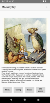
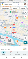
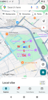
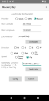
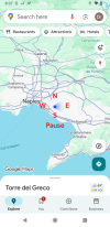
The other project - MockMyDay - speaks for itself. It's a mock location app with an live overlay/drawover. You put it on top of Google Maps and drive or walk or run or fly around as if you were there. The series of screen caps shows setting up in Paris, France with a planned drive to Brussels, Belgium. Start the app and bring up Google Maps. We're in Paris heading north. Let's say we want to go east. Tap the "E" button. Obviously, the screencaps don't show motion, but the map's blue dot is moving around as landmarks go by. The next series puts us in Pompei, Italy for a flight to Rome. Back to Google Maps which shows us in southern Italy. If you feed it an itinerary in the form of latlon wayponts, it will follow it. Etc.
When I'm told that GNSS (aka, fused location) is better for me, I immediately bristle. Furthermore, when I'm told that there is another satellite system out there, but that I can't use it, either as a result of government regulation or Android-imposed rules, I immediately want to know what everybody is afraid of. So, with a cheap Chinese usb "gps" receiver in hand, we have YicandYac which only uses Beidou satellites for positional fix. Why YicandYac? Well, by the time you find a cheap Chinese receiver that actually works, you start referring to them by little nicknames. Yac finally worked after hours and days trying to get Yic to do what it was told to do.
The other project - MockMyDay - speaks for itself. It's a mock location app with an live overlay/drawover. You put it on top of Google Maps and drive or walk or run or fly around as if you were there. The series of screen caps shows setting up in Paris, France with a planned drive to Brussels, Belgium. Start the app and bring up Google Maps. We're in Paris heading north. Let's say we want to go east. Tap the "E" button. Obviously, the screencaps don't show motion, but the map's blue dot is moving around as landmarks go by. The next series puts us in Pompei, Italy for a flight to Rome. Back to Google Maps which shows us in southern Italy. If you feed it an itinerary in the form of latlon wayponts, it will follow it. Etc.