Yet another compass application? Well, Yes and No. The idea behind COMPASS ULTIMATE is to combine the possibilities of today's technology of a modern smart phone with an old-fashioned compass. The goal is to use all available offline information to give the user as much independence as possible from modern online navigation tools. The software can be used while hiking, on a boat, in a plane, in a car or in a train. A connection to the internet or mobile network is not required. Maybe this is also a nice way to give your old smart phone a second chance. The name of the software is intended to indicate a goal, not the current state of the software. Navigation and use of the software is highly dependent on the user's understanding. You should know about the basics of navigation on earth, especially GPS.
In first line the software was developed to support your freetime activities with navigational information. COMPASS ULTIMATE is free of advertising and works up to Android version 16 at the moment.
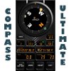
Range of functions:
- clearly structured 3D user design
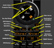
- 3D compass rose incl. north index
- Complete documentation included within the software
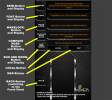
- Use of a combination of gyroscope und GNSS informations to display following data in realtime
- Calibration accuracy of the internal gyros
- Amount of satellites to get a position fix
- 3 modes for measurements (metric, imperial, nautical)
- Accuracy of the GNSS data used
- Height above sealevel (or WGS84 ellipsoid depending on availability)
- Inclination / declination
- Movement direction (heading or bearing)
- Longitude / latitude
- Speed of movement
- Two separated distance counter (odometer)
- 5 multifunctional buttons für configuration, setup and controlling of the app
- 8 background layer free to choose of
- Several configurations for displaying fonts on the displays
- Wakelock control
- 2 general modes of work (Hiking-Mode / Car-Mode)
- In connection with GNSS optional display of sun and moon on the compass rose
- Graphical representation of the twilight times and the phases of the moon
- Timezone information
- Complete Integration of the WMM (World Magnetic Model)
The software is free of charge. So take your time, test it, if you like it and you find it useful or it is inspiring you to something new, please donate some money. I invested hundreds of hours to make it work.
The software is not available at the google playstore. You can get it directly from my website.
Please download and read the description of that very complex app. It is more inside than you may think, so using it in a right way is essentially for your own satisfaction while using this app. This is not an app you can install and immediately use all of its functions without knowledge. All is written within the documentation.
A very special THANK YOU from me to the following members of the forum:
Klaus Christl (Switzerland) for helping to implement various software mechanisms for smooth rotation and visualisation
David Erez (Israel) for developing a class to decode the coefficient file of the world magnetic model (COF file) and sharing his software with me
Johan Schoeman (South Africa) for the idea and programming principle of the 7-segment design elements and some small elegant code snippets used within this software, testing this software again and again (below the equator everything changes, you know...") )
)
Erel Uziel (Israel) for the great application development interface B4A
Hans Zekl (no forum member, Germany) for his patience with me and his support in my development of the "spherical trigonometry for ANDROID", which is used in the astronomical calculations of this programme.
Cheers to all of you, hope you like my app, it's function and the graphical design (honestly, I am bored by "flat" 2-dimensional app-designs and love to convert a smartphone by using good graphics and 3D-effects into something totally different in the same way I hate all the daily-changing policies of GOOGLE).
Yours, BlueVision
Berlin, September 2022 (updated 2026)
In first line the software was developed to support your freetime activities with navigational information. COMPASS ULTIMATE is free of advertising and works up to Android version 16 at the moment.
Range of functions:
- clearly structured 3D user design
- 3D compass rose incl. north index
- Complete documentation included within the software
- Use of a combination of gyroscope und GNSS informations to display following data in realtime
- Calibration accuracy of the internal gyros
- Amount of satellites to get a position fix
- 3 modes for measurements (metric, imperial, nautical)
- Accuracy of the GNSS data used
- Height above sealevel (or WGS84 ellipsoid depending on availability)
- Inclination / declination
- Movement direction (heading or bearing)
- Longitude / latitude
- Speed of movement
- Two separated distance counter (odometer)
- 5 multifunctional buttons für configuration, setup and controlling of the app
- 8 background layer free to choose of
- Several configurations for displaying fonts on the displays
- Wakelock control
- 2 general modes of work (Hiking-Mode / Car-Mode)
- In connection with GNSS optional display of sun and moon on the compass rose
- Graphical representation of the twilight times and the phases of the moon
- Timezone information
- Complete Integration of the WMM (World Magnetic Model)
The software is free of charge. So take your time, test it, if you like it and you find it useful or it is inspiring you to something new, please donate some money. I invested hundreds of hours to make it work.
The software is not available at the google playstore. You can get it directly from my website.
Please download and read the description of that very complex app. It is more inside than you may think, so using it in a right way is essentially for your own satisfaction while using this app. This is not an app you can install and immediately use all of its functions without knowledge. All is written within the documentation.
A very special THANK YOU from me to the following members of the forum:
Klaus Christl (Switzerland) for helping to implement various software mechanisms for smooth rotation and visualisation
David Erez (Israel) for developing a class to decode the coefficient file of the world magnetic model (COF file) and sharing his software with me
Johan Schoeman (South Africa) for the idea and programming principle of the 7-segment design elements and some small elegant code snippets used within this software, testing this software again and again (below the equator everything changes, you know...
)Erel Uziel (Israel) for the great application development interface B4A
Hans Zekl (no forum member, Germany) for his patience with me and his support in my development of the "spherical trigonometry for ANDROID", which is used in the astronomical calculations of this programme.
Cheers to all of you, hope you like my app, it's function and the graphical design (honestly, I am bored by "flat" 2-dimensional app-designs and love to convert a smartphone by using good graphics and 3D-effects into something totally different in the same way I hate all the daily-changing policies of GOOGLE).
Yours, BlueVision
Berlin, September 2022 (updated 2026)
Attachments
Last edited: