I have received a request for a copy of my GPSlog for android, which is still under development. It is at a stage that is functional and of potential interest to others, so I post the alpha version here.
The primary functionality missing is the saving and retrieval of locations. The GPS functions and compass work well. There is a lot of extraneous code to be cleaned out, as well as some documentation to be done.
CAVEAT: This was developed for 480 x 800 resolution. It works on my Droid2 at 480x854 but will not display properly at lower resolutions. This is on my do-do list.
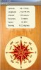
As will all android compasses, you should wave the device in a figure-8 pattern prior to relying on the compass display. On wave does it for me.
One nice freature is an option to have the GPS turned on and off automatically when the program is activated or paused. Not all devices respond well to the automatic GPS activation but if your does, this is a very convenient feature.
I look forward to any comments or suggestions for improvements.
19 July 2011
Update allows saving of locations and calculation of distance between two locations. I still need to add editing features and tweak to run on tablets. Right now I am moving two households 200km so that is taking all my time. I will finish the developement after the move, unless the move finishes me first.
******************************************************
17 December 2011
Updated many things. Took this long because (1) I was moving two households a fair distance, and (2) I was very sloppy in my original coding which made updating the code a frustrating experience. Please let me know if you see any remaining bugs.
Updates:
1. Everything is scaled at runtime so the program hopefully will function on any device (runs fine on my Droid2 phone and my Iconia a500 tablet).
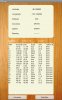
2. Only the original units are stored and retrieved. Units are displayed according to user preference (eg. degrees, metric).
3. You can now edit the descriptions in the log.
4. You can now delete log entries.
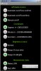
5. The most fun change (for me at least) is the ability to map the current location, and any of the locations in the log.
6. If a log page has not been created, then a sample log page is created and loaded (Mt. Rainier, Niagra Falls, Festung Marinberg, Panama Canal).
7. Added an About page.
Ideas for the future:
Export log file (text, kml)
Sort by Description, Latitude, Longitude, or Altitude
Manual adding of log entries
The latest version (1.1) is attached. Again, bug reports would be welcome!
Version 1.2 (May 2014). Added satellite information and help page.
The primary functionality missing is the saving and retrieval of locations. The GPS functions and compass work well. There is a lot of extraneous code to be cleaned out, as well as some documentation to be done.
CAVEAT: This was developed for 480 x 800 resolution. It works on my Droid2 at 480x854 but will not display properly at lower resolutions. This is on my do-do list.
As will all android compasses, you should wave the device in a figure-8 pattern prior to relying on the compass display. On wave does it for me.
One nice freature is an option to have the GPS turned on and off automatically when the program is activated or paused. Not all devices respond well to the automatic GPS activation but if your does, this is a very convenient feature.
I look forward to any comments or suggestions for improvements.
19 July 2011
Update allows saving of locations and calculation of distance between two locations. I still need to add editing features and tweak to run on tablets. Right now I am moving two households 200km so that is taking all my time. I will finish the developement after the move, unless the move finishes me first.
******************************************************
17 December 2011
Updated many things. Took this long because (1) I was moving two households a fair distance, and (2) I was very sloppy in my original coding which made updating the code a frustrating experience. Please let me know if you see any remaining bugs.
Updates:
1. Everything is scaled at runtime so the program hopefully will function on any device (runs fine on my Droid2 phone and my Iconia a500 tablet).
2. Only the original units are stored and retrieved. Units are displayed according to user preference (eg. degrees, metric).
3. You can now edit the descriptions in the log.
4. You can now delete log entries.
5. The most fun change (for me at least) is the ability to map the current location, and any of the locations in the log.
6. If a log page has not been created, then a sample log page is created and loaded (Mt. Rainier, Niagra Falls, Festung Marinberg, Panama Canal).
7. Added an About page.
Ideas for the future:
Export log file (text, kml)
Sort by Description, Latitude, Longitude, or Altitude
Manual adding of log entries
The latest version (1.1) is attached. Again, bug reports would be welcome!
Version 1.2 (May 2014). Added satellite information and help page.
Attachments
Last edited:
