Hi,
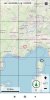
This b4Xlib contains a custom view (cvMap) which can display Open Street Map.
 View attachment 109081
The tiles are retrieved from the internet and cached in a database. You can add shapes and images on the map.
UI :
- Lat/lng Center of the map
- Zoom Level
- Compass Direction with rotation
- Scale
- Button Menu
- Grid
- Center
- GPS position and bearing
Event :
- ready
- Lat/lng changed
- Zoom Level Changed
- Compass Direction Changed
- Shape Clicked
- Map Clicked
- Center Lat/lng clicked
- Button Menu clicked
- Scale clicked
- Compass Clicked
- GPS Clicked
Tile Server
2 new properties :
Dependencies :
- Core
- SQL
- OKHttpUtils2
- XUI
- XUI views
Other files in the b4xlib :
- coMapUtilities : code module with Types, functions, helpers
- clTileManager : standard class module to load tile from database and/or internet and save them into the database
- clMapShapeCirgle : standard class to draw circle on the map
- clMapShapeLine : standard class to draw line on the map
- clMapShapePolygon : standard class to draw polygon on the map
- clMapShapeImage : standard class to draw image on the map
- layout cvmap.bal and cvmap.bjl
- images for the compass and gps
How to use it :
- Just add the cvMap custom view with the designer
- create sub to handle events if necessary
- set options (lat/lng, zoom.....)
B4A example and B4J example included
spsp
This b4Xlib contains a custom view (cvMap) which can display Open Street Map.
The tiles are retrieved from the internet and cached in a database. You can add shapes and images on the map.
UI :
- Lat/lng Center of the map
- Zoom Level
- Compass Direction with rotation
- Scale
- Button Menu
- Grid
- Center
- GPS position and bearing
Event :
- ready
- Lat/lng changed
- Zoom Level Changed
- Compass Direction Changed
- Shape Clicked
- Map Clicked
- Center Lat/lng clicked
- Button Menu clicked
- Scale clicked
- Compass Clicked
- GPS Clicked
Tile Server
2 new properties :
- tileServer : Choose your tile server (see https://wiki.openstreetmap.org/wiki/Tile_servers), default : https://a.tile.openstreetmap.org/
- userAgent : request to the tile server requires a user agent in the header. You can now set your own user Agent : default : Mozilla/5.0 (Windows NT 6.1; WOW64; rv:27.0) Gecko/20100101 Firefox/27.0
Dependencies :
- Core
- SQL
- OKHttpUtils2
- XUI
- XUI views
Other files in the b4xlib :
- coMapUtilities : code module with Types, functions, helpers
- clTileManager : standard class module to load tile from database and/or internet and save them into the database
- clMapShapeCirgle : standard class to draw circle on the map
- clMapShapeLine : standard class to draw line on the map
- clMapShapePolygon : standard class to draw polygon on the map
- clMapShapeImage : standard class to draw image on the map
- layout cvmap.bal and cvmap.bjl
- images for the compass and gps
How to use it :
- Just add the cvMap custom view with the designer
- create sub to handle events if necessary
- set options (lat/lng, zoom.....)
B4A example and B4J example included
spsp
Attachments
Last edited:
")
